Title here
Summary here
Ground Detail Adjustment is available for both MSFS 2020 and MSFS 2024 in version 10.1.0 or later. It changes how much ground detail the simulator requests; it does not restore the old 512 × 512 tile method.
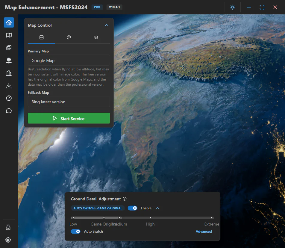
Higher levels request more map data and use more network bandwidth, RAM, VRAM, CPU, and GPU resources. Reduce the level if you see stuttering, long loading times, or instability.
Open the advanced Ground Detail options to enable Auto Switch. The default profile uses the game’s original detail below 10,000 feet and Medium at or above 10,000 feet. You can change the switching altitude and both detail levels for your aircraft and system.
Changes apply during the current flight. If applying or restoring a level fails, the app displays an error and leaves the feature disabled.
Building Enhancement was introduced in version 10.0.0 and works only with MSFS 2024. It updates building coverage using newer building data for approximately 700 million buildings worldwide. It does not replace Microsoft’s photogrammetry buildings.
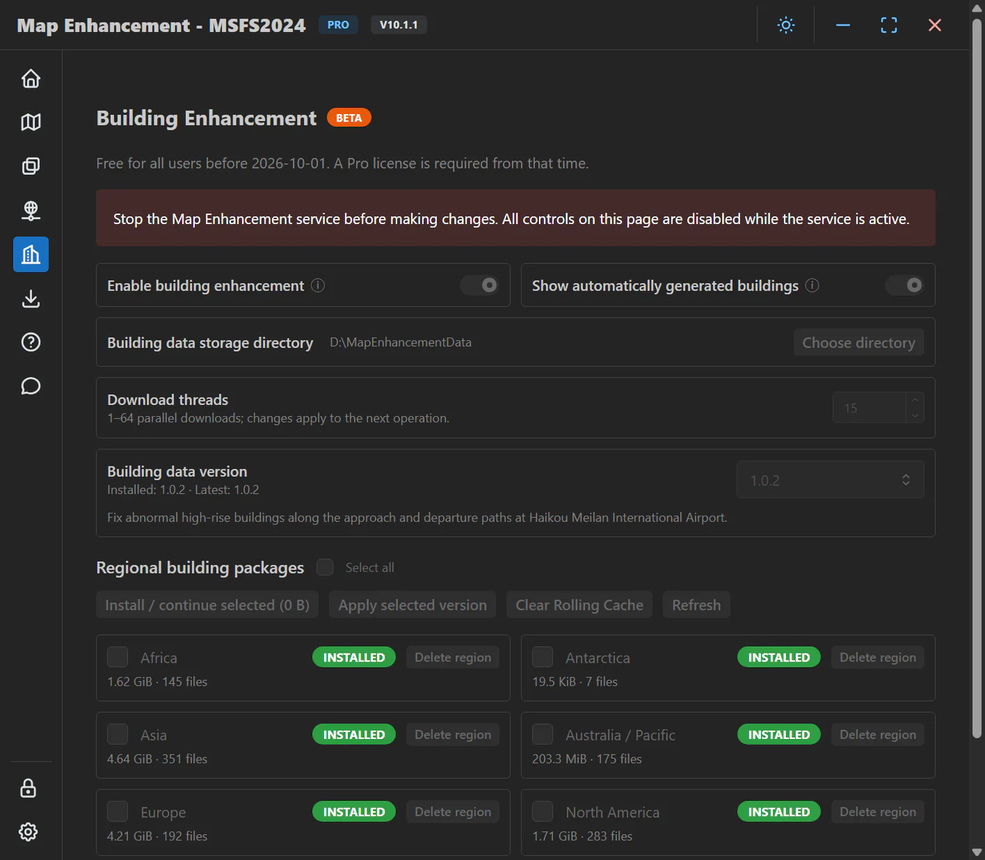
The page also lets you select a building-data version, update to a newer version, or roll back. Stop Map Enhancement and exit MSFS before installing, deleting, updating, rolling back, or changing building display options.
Building Enhancement is free for all users until October 1, 2026. A Pro license is required after that date to download, update, or use building packages.
The difference is most visible where the simulator uses automatically generated buildings and where OpenStreetMap data has changed since Microsoft’s dataset was created. The change can be especially noticeable in China. Areas covered by photogrammetry continue to use Microsoft’s photogrammetry, so they may look unchanged or have a different color style from the surrounding imagery.
If the simulator crashes during loading, buildings look mixed, or an old version remains visible, exit the simulator and use the building-data Rolling Cache cleanup action before trying again.
Map Enhancement has two different caches:
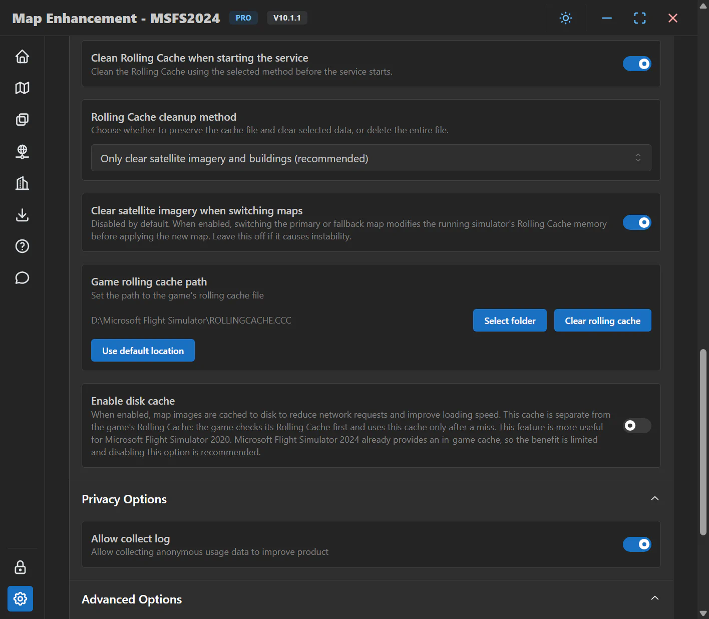
ROLLINGCACHE.CCC. MSFS 2020 provides in-game controls for it. The targeted actions below are for MSFS 2024 and remove old satellite imagery or building data.| Situation | Action |
|---|---|
| Old imagery remains after a color adjustment | Use Clear cache on the color settings page to clear satellite imagery only. |
| Switching the primary or fallback map | Optionally enable Clear satellite imagery when switching maps. It is off by default and attempts targeted cleanup when enabled. If it causes instability, turn it off and clean the cache after exiting the game instead. |
| Changing Building Enhancement, its data version, or building display options | Exit MSFS and stop the enhancement service before making changes, then follow the cleanup prompt. Only clear satellite imagery and buildings (recommended) clears those two data types. |
| Clearing old data before your next flight | Exit MSFS, select a cleanup mode in Settings, and choose Clear rolling cache. Alternatively, enable Clean Rolling Cache when starting the service to use the selected mode at startup. |
The general Rolling Cache cleanup button does not always delete the whole file. Targeted mode first tries to retain other cached data; however, if targeted cleanup fails while MSFS is closed, the general cleanup action may fall back to deleting the entire cache file. Delete the entire Rolling Cache file requires MSFS to be closed and makes the game download cached data again. Color and map-switch cleanup do not automatically fall back to whole-file deletion.
Cache cleanup does not force the simulator to redraw terrain already on screen. After changing colors or maps, move to a new area or exit and reload the flight before comparing. You can also move or zoom to another location on the world map to inspect newly loaded tiles. Do not repeatedly delete caches just because the current view has not changed.
Photogrammetry areas still use Microsoft’s scanned 3D data and are not replaced by the selected map or color adjustments. If only those areas look different, temporarily disable photogrammetry and compare the same location, then restore the setting.
Map Enhancement’s Game rolling cache path must match the path actually used by MSFS 2024. Use default location is appropriate only if the game also uses its default path. For a missing-file or skipped/failed-cleanup message, check the path and whether the game is running, and keep the full error. Do not create an empty ROLLINGCACHE.CCC or delete other directories to bypass the message.
If you keep the same maps and building settings and everything looks correct, you do not need to delete the entire Rolling Cache at every startup. You can disable startup cleanup to retain existing data, then use the appropriate action above when changing sources, changing buildings, or troubleshooting mixed old data. The first load after cleanup is usually slower and uses more bandwidth.
Turn on Enable Seasonal Effects on the MSFS 2020 Map Enhancement home page, then set Season override. A Pro license is required. MSFS 2024 already has its own seasonal system, so the following options apply only to MSFS 2020.
Startup Season only applies during Auto mode’s initial phase; it is not a substitute for a fixed season. If Season override is absent, your version does not support a fixed season.
New requests use the new season setting, but already loaded scenery is not immediately redrawn. If the old season remains, exit the simulator and check the application disk cache and MSFS 2020 Rolling Cache as described in Cache Options, then reload the flight. You do not need to change the flight date or turn off real-time weather.
The original map source lets you return to Microsoft’s imagery without uninstalling Map Enhancement. Use it when comparing providers or troubleshooting an area. Color adjustment is not available for the original map because selecting it switches the complete map request back to Microsoft’s source.